>> slide image left >> 18 kilometres south of the Canadian border, 108 kilometres east of Vancouver, Canada, 3,286~3,288 m (10,786 ft) Mount Baker (Kulshan) Stratovolcano is where the westward moving North America Tectonic Plate, collides with the Juan de Fuca Tectonic Plate. It is active. The United States Geologic Survey rates it a VERY HIGH RISK. If the wind is from the east, the tephra will fall on Vancouver, Canada in about an hour.
Hyperlinks your own social media.
Our group of nine climbers summited Mt Baker in Washington's North Cascades mountain range. Near the summit, we stopped for a break at which time I videotaped and recorded the sound emanating from its crater. The hissing sound originates from the crater whereas the roaring sound is the wind.
Sherman Crater is at 2925 m
(9,000 feet) on the Southern Flank
of Mount Baker Stratovolcano
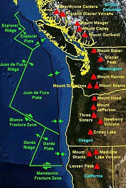
Mount Baker, also known as Koma Kulshan or simply Kulshan, is an active glaciated andesitic stratovolcano in the Cascade Volcanic Arc and the North Cascades of Washington in the United States. Mount Baker has the second-most thermally active crater in the Cascade Range after Mount Saint Helens. Wikipedia
Did you know: The mountain is drained in the north by North Fork Nooksack River, west by Middle Fork Nooksack River, and east by Baker River.volcanolive.com
This video was taken July 6, 2010 by Dave Tucker. It shows the fumaroles just inside the west rim of Sherman Crater, at 2925 m (9600 feet) on Mount Baker Stratovolcano. MountBaker has the second-most thermally active crater in the Cascade Range after Mount Saint Helens. The high wall of rock is a stack of lava flows erupted from the summit, 1000 feet above the fumaroles. These lava flows are altered by sulphur-rich gas rising from the magma beneath the volcano. Samples of gas were collected from the fumaroles, which vent water vapor (H2O), carbon dioxide (CO2), Hydrogen Sulfide (H2S), and other gases from within the volcano. People on the trip were volunteers organized by Mount Baker Volcano Research Center, Bellingham Washington. For more information, contact Mount Baker Volcano Research Center, University of Western Washington: http://mbvrc.wwu.edu
The present-day cone of Mount Baker is relatively young; it is perhaps less than 100,000 years old.[5] The volcano sits atop a similar older volcanic cone called Black Buttes, which was active between 500,000 and 300,000 years ago.[25] Much of Mount Baker's earlier geological record eroded away during the last ice age (which culminated 15,000–20,000 years ago), by thick ice sheets that filled the valleys and surrounded the volcano. In the last 14,000 years, the area around the mountain has been largely ice-free, but the mountain itself remains heavily covered with snow and ice.[26]
Isolated ridges of lava and hydrothermally altered rock, especially in the area of Sherman Crater, are exposed between glaciers on the upper flanks of the volcano; the lower flanks are steep and heavily vegetated. Volcanic rocks of Mount Baker and Black Buttes rest on a foundation of non-volcanic rocks.[5]
Magmatic eruptions have produced tephra, pyroclastic flows, and lava flows from summit vents and the Schriebers Meadow cinder cone. The most destructive and most frequent events at Mount Baker have been lahars or debris flows and debris avalanches; many, if not most, of these were not related to magmatic eruptions, but may have been induced by magma intrusion, steam eruptions, earthquakes, gravitational instability, or possibly even heavy rainfall.[26][27][29]