Universal Coordinated Time UTC – ZULU is a 24 hour clock. During an eruption, if the wind is from the east at 10,000 feet (outflow), the tephra will fall on Vancouver, Canada in about an hour. If the Kulshan Wind is from the west (inflow) the tephra will fall on Merritt, BC in about 40 minutes. There are extremes in preparedness, of course. As a basis of my work I use the 2015 Profile of Earthquake Risk in the District of North Vancouver by Earthquake Canada, wherein they state that there is 30% chance of a M7.3 in the middle of the Salish Sea, say between North Vancouver, Nanaimo and Victoria, in the next 50 years, that will bring down 839 buildings, just among the 80,000 residents in the District of North Vancouver. Hyperlinked where I can. Good morning, everyone. We begin to deal with BIG (MEGA) EARTHQUAKES at New Cascadia Dawn © ™ ® - Cascadia Rising - M9 to M10+, An Intelligent Grandfather's Guides © ™ ® next, Mount Baker Stratovolcano (background) © ™ ® / Kulshan Stratovolcano © ™ ®, Simon Fraser University (foreground) ~ Image by Stan G. Webb - In Retirement © ™ ®, An Intelligent Grandfather's Guides © ™ ® next, The Man From Minto © ™ ® - A Prospector Who Knows His Rocks And Stuff © ™ ® Learn more about the Cascadia Volcanic Arc © ™ ® (Part of Pacific Ring of Fire) Cascadia Volcanoes © ™ ® and the currently active Mount Meager Massif © ™ ®, part of the Cascadia Volcanic Arc © ™ ® [ash flow, debris flows, fumaroles and hot springs], just northwest of Pemberton and Whistler, Canada ~ My personal interest in the Mount Meager Massif © ™ ® is that the last volcanic vent blew north, into the Bridge River Valley [The Bridge River Valley Community Association (BRVCA), [formerly Bridge River Valley Economic Development Society], near my hometown. I am the Man From Minto © ™ ® - A Prospector Who Knows His Rocks and Stuff © ™ ® (Severe). Earthquake Drill 3rd Thursday in October 19, 2023 at 10:20 AM Pacific I grew up in small towns and in the North where the rule is share and share alike. So, I'm a Creative Commons type of guy. Copy and paste ANY OF MY MATERIAL anywhere you want. Hyperlinks to your own Social Media are at the bottom of each post. Creative Commons License
This work is licensed under my Creative Commons Attribution 4.0 International License. SOUND ON >> TO WATCH FULL SCREEN start the video and click on the YouTube Icon at the bottom and expand there. Later When you close that window you will be brought back here.

Monday, November 12, 2018

November Dawn Over Kulshan Stratovolcano© / Mount Baker Stratovolcano©

https://youtu.be/2NZoXwM67z0 [0:32 seconds]

Others:  Images for November Dawn Over Mount Baker ...
Kulshan has erupted numerous times in (LummiQwú’mə KwəlshéːnNooksackKw’eq Smaenit or Kwelshán), also known as Koma Kulshan or simply Kulshan, Sto:Lo Koma Kulshan or simply Kulshan?, has erupted 13 times in recorded history. Its last eruption was in 1880.

Baker | Volcano World | Oregon State University   [volcano.oregonstate.edu/baker]


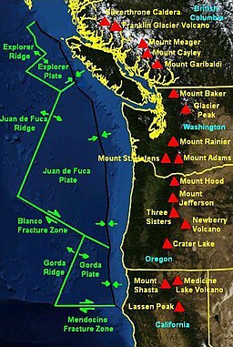
Mt. Baker is an isolated stratovolcano in northern Washington. It is the northernmost of the Cascade volcanoes in the United States. Most of the summit of the volcano is covered by glaciers. Because of this, some First Nations gave Mt. Baker a name meaning "White Steep Mountain."; Sto:lo "Father", with Mount Cheam being mother. 
Eastonterm.jpg
Image: Easton Glacier
near the summit.

Kulshan Stratovolcano© / Mount Baker Stratovolcano© has been very active over the last 10,000 years. Over that time it has had one pyroclastic
flow, at least four small tephra eruptions, at least two lava flows and at least eight mud flows. Mud flows remain the largest hazard on Kulshan Stratovolcano© / Mount Baker Stratovolcano©. Kulshan / Mt. Baker erupted in 1843. This eruption resulted in the deaths of many fish in the Baker River, a large forest fire, and the dropping of volcanic ash. The release of steam occurred at Mt. Baker in 1975-6, but no eruption followed this event. One of the most recent formations on Baker is a ~760 m (~2500 ft) wide, ~100m (~330ft) high cinder cone and its ~11 km (~7 mile) long lava flow at Schreibers Meadow.
Sources of Information:
Wood, Charles A. and Kienle, Jurgen, "Volcanoes of North America: United States and Canada," Cambridge University Press, Cambridge, MA, 1990, 354 pp.


Saturday, November 10, 2018

Lahar / Debris Flow Potential from 3,286 m (10,781 ft), Kulshan Stratovolcano© / Mount Baker Stratovolcano© - 13 July '11: Mer de Glace Debris Flow

This might be what a lahar / debris flow  coming down from the glaciated ice sheet on top of 3,286 m (10,781 ftMount Baker Stratovolcano.  It would likely look like:
13 July '11: Mer de Glace Debris Flow

Bruce Reeves
Published on Jul 31, 2011
The two summits are located on the west ridge of the Aiguille Verte (4,122 m) and are connected to each other by the Brèche du Dru(3,697 m). The north face of the Petit Dru is considered one of the six great north faces of the Alps.

:
Drus-2006.jpgDebris Flow above Mer de Glace Glacer, below Les Drus peak, near Chamonix, France, shot from about 500 yards away. Significantly condensed; debris flow continued for over 45 minutes.  [Wikipedia: TThe mountain's highest summit is Aiguille du Dru (also the Dru or the Drus; French, Les Drus) is a mountain in the Mont Blanc massif in the French Alps. It is situated to the east of the village of Les Praz in the Chamonix valley. "Aiguille" means "needle" in French.
  • Grande Aiguille du Dru (or the Grand Dru) 3,754 m
Another, slightly lower sub-summit is:
  • Petite Aiguille du Dru (or the Petit Dru) 3,733 m.
The southwest "Bonatti" pillar and its eponymous climbing route were destroyed in a 2005 rock fall.[2][3]


At 3,286 m (10,781 ft), Mount Baker Stratovolcano is the third-highest mountain in Washington and the fifth-highest in the Cascade Range, if Little Tahoma Peak, a sub-peak of Mount Rainier, and Shastina, a sub-peak of Mount Shasta, are not counted.

Wednesday, November 7, 2018

Lessons from Popmpii - The Worst Part Of Pompeii's Destruction Isn't What You Think

https://youtu.be/rduUDoy3dY  [11:16 minutes]
 
#Pompeii
#MountVesuvius
by:  Grunge
Published on Apr 10, 2019
You might be forgiven for thinking that the most disturbing part of the eruption
of Mount Vesuvius in 79 A.D. was the sheer suddenness of Pompeii’s
destruction. But while the town’s destruction was unspeakably
tragic, the speed at which it happened wasn’t nearly the worst
thing about it. Two festivals happening in the town at the same time
meant the tragedy at Pompeii ended up so much worse than it should
have been. According to the book Pompeii: An Archaeological Guide,
the Pompeians were in the middle of a multi-day celebration in honor
of the emperor Augustus. Known today as the first emperor of the
Roman Empire, Augustus had passed 65 years earlier and had just been
made a god — as well as having the month of August named after him.
Pompeii’s streets were filled with public celebrations including
street musicians, fortune tellers, plays, and athletic events. Many
of those performers and athletes came from outside Pompeii to take
part in the event, as did the visitors and tourists who came to see
them. We can't know exactly how many extra people were in the town at
the time of its destruction, but it is certainly a lot more lives
were lost than might have happened if the eruption had happened a
month later. Even worse, the day before the eruption was Vulcanalia,
the festival of the god Vulcan — otherwise known as the god of fire
and volcanoes. It wasn't so much that the people of Pompeii didn't
get a warning that Mount Vesuvius was going to erupt, because there
definitely would have been smoke, small earthquakes, and loud
rumblings at the very least. It was more that, because of Vulcanalia,
they would have interpreted these signs as good omens from the god
rather than warnings to get out of Dodge. As far as the townspeople
cared, these warnings were simply signs that Vulcan was busy at his
forge inside Mount Vesuvius, perfectly happy that everyone was
celebrating his special day. Watch the video to lean why the worst
part of Pompeii's destruction isn't what you think.
#Pompeii
#MountVesuvius
Unheeded |
0:16
Weird weather |
1:47
Frozen in time |
3:05
Screaming death |
4:33
Beyond Pompeii |
5:49
Defiled |
6:57
Neglect |
8:18
The future |
9:40

Thursday, November 1, 2018

Sunday, October 28, 2018

Mt Baker's hissing volcanic crater

https://youtu.be/caWkjzcHgNk [0:20 seconds]

Mount Baker Stratovolcano©


CascadesHiker
Published on Jul 12, 2007
Our group of nine climbers summited Mt Baker in Washington's North Cascades mountain range. Near the summit, we stopped for a break at which time I videotaped and recorded the sound emanating from its crater. The hissing sound originates from the crater whereas the roaring sound is the wind.
Sherman Crater is at 2925 m
(9,000 feet) on the Southern Flank
of Mount Baker Stratovolcano

Mount Baker, also known as Koma Kulshan or simply Kulshan, is an active glaciated andesitic stratovolcano in the Cascade Volcanic Arc and the North Cascades of Washington in the United States. Mount Baker has the second-most thermally active crater in the Cascade Range after Mount Saint Helens. Wikipedia
Elevation3,286 m [10,781 feet]
Topo mapUSGS Mount Baker
Did you knowThe mountain is drained in the north by North Fork Nooksack River, west by Middle Fork Nooksack River, and east by Baker River.volcanolive.com

Cascade Volcanic Arc.jpg

Saturday, October 27, 2018

Tour of Sherman Crater, Mount Baker


D Tucker
Published on Jul 28, 2011
This video was taken July 6, 2010 by Dave Tucker. It shows the fumaroles just inside the west rim of Sherman Crater, at 2925 m (9600 feet) on Mount Baker Stratovolcano.  Mount Baker has the second-most thermally active crater in the Cascade Range after Mount Saint Helens.  The high wall of rock is a stack of lava flows erupted from the summit, 1000 feet above the fumaroles.  These lava flows are altered by sulphur-rich gas rising  from the magma beneath the volcano. Samples of gas were collected from the fumaroles, which vent water vapor (H2O), carbon dioxide (CO2), Hydrogen Sulfide (H2S), and other gases from within the volcano. People on the trip were volunteers organized by Mount Baker Volcano Research Center, Bellingham Washington. For more information, contact Mount Baker Volcano Research Center, University of Western Washington:
http://mbvrc.wwu.edu

From Wikipedia -  Mount Baker
The present-day cone of Mount Baker is relatively young; it is perhaps less than 100,000 years old.[5] The volcano sits atop a similar older volcanic cone called Black Buttes, which was active between 500,000 and 300,000 years ago.[25] Much of Mount Baker's earlier geological record eroded away during the last ice age (which culminated 15,000–20,000 years ago), by thick ice sheets that filled the valleys and surrounded the volcano. In the last 14,000 years, the area around the mountain has been largely ice-free, but the mountain itself remains heavily covered with snow and ice.[26]
Isolated ridges of lava and hydrothermally altered rock, especially in the area of Sherman Crater, are exposed between glaciers on the upper flanks of the volcano; the lower flanks are steep and heavily vegetated. Volcanic rocks of Mount Baker and Black Buttes rest on a foundation of non-volcanic rocks.[5]
Deposits recording the last 14,000 years at Mount Baker indicate that Mount Baker has not had highly explosive eruptions like those of other volcanoes in the Cascade Volcanic Arc, such as Mount St. HelensGlacier Peak, or the Mount Meager massif, nor has it erupted frequently. During this period, four episodes of magmatic eruptiveactivity have been recently recognized.[27][28]
Magmatic eruptions have produced tephrapyroclastic flows, and lava flows from summit vents and the Schriebers Meadow cinder cone. The most destructive and most frequent events at Mount Baker have been lahars or debris flows and debris avalanches; many, if not most, of these were not related to magmatic eruptions, but may have been induced by magma intrusion, steam eruptions, earthquakes, gravitational instability, or possibly even heavy rainfall.[26][27][29]